To Everest Base Camp – Journal
54 min read
The place on the planet closest to heaven sure looked like his playground from up there around the end of October…only it was to get a few new visitors trying hard to prove a point to themselves..

..this is about Aruna & my journey to the bottom of the top of the world..

..the base camp is on the Kumbhu glacier which covers the slopes of Everest to the west and south….its fed by the glacier bed of the western cwm, an enclosed valley of ice between Everest and the Lhotse – Nuptse ridge to the south. Glacial action has been the primary force behind the heavy and continuous erosion of Everest and the other high Himalayan peaks. This glacier moves about a foot a day but most of the Himalayan glaciers are on the retreat due to global warming . It melts into the Lobujya river of Nepal, which flows southward as the Imja river to its confluence with the Dudh Kosi river which most of our foothill trail followed ..

..often asked the ‘why’ question – why put our lives on hold to focus entirely on this one pursuit , subject ourselves to freezing temperatures and lack of oxygen for long periods of time, not to mention the immense physical challenge . Thats hard to answer as this is beyond just adventure , the feeling of being closest to the highest peaks of the planet sans it all…but sure not only that..
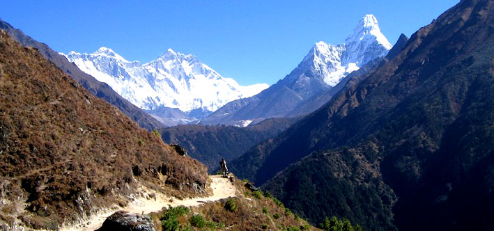
heres a description of the trail with the peaks..

..the trail we followed from Luklai in red…we did it the tough way..in about 30 % less time taxing our minds & bodies to the limit due to shortage of time , but ideally this should be done passionately & very slowly..

.. just reaching the base of Mount Everest is quite an endurance test if we look at just the pain…demanding good fitness and mental strength. Of course we were nervous , we’d be fools not to be…but it’s certainly true that people do die mostly on Everest & quite a few on the trail almost every year…however, it’s interesting to ask ourselves why a few deaths on Everest evoke far more empathy and emotion & and often criticism than deaths caused by other natural disasters, road accidents, drug problems or illness. Is it because we all relate to adventure in some form , the predetermined, articulated goal of a climber, sailor or balloonist will naturally capture our human emotions? or is there a pinch of spirituality attached with the very theme ?
whatever…we found this warning on our way…

so I think its about how you address it ” not the number of breaths in you life that count..but the number of moments that take your breath away “
…and why not…

Our Everest, is in fact its base…or the nearest point to feel its magnetism at the strongest but all the same could be said for whatever your Everest is and we hope our journey might just inspire you to dare to work towards your own wildest dreams. We ‘re back to tell you the story but I also believe…we’re only just about as big as the dreams we dare to live..

Day 1
..a bit of history…we’d been planning this trip for about 6 months but two months before the planned departure date we got to know all kolkata – katmandu tickets were sold out & katmandu lukla tickets were very unpredictable ..somehow though we managed through Aruna’s friend’s husband Basu-da (a great man I owe this trip to him) an IC employee.. he not only managed to get our tickets but also helped to get return tickets for Kat – Lukla on Yeti Air through their country manager at Nepal. That very evening Hamptu called & wanted to join us. Major problem in getting his tickets done but finally with a lot of effort & good luck they were confirmed. He was to travel across the planet in about 14 hrs & join us the following day at Katmandu. Both Aruna & I were a bit tired from the CRSRC meet at Burnpur a couple of days back where we both took care in vain not to indulge too much, but as expected it was 2 days of junk food, late nights , football, swimming at odd hours & sleepless nights not forgetting the drive for almost 500kms on the NH ..starting from home…I was quite taken aback as I was supposed to counsel her over days this time, and all that was suddenly just a thing of the past…she was all set packing our sacs for us…realised late my little girl has grown up when she posed for this saying ‘trek well’…floored !

..departure finally..all clean & bathed for the days ahead..

..flying into the Himalayan kingdom is quite beautiful from the sky.. ..thats the third pole from about 37,000 ft…if we only knew then how far its on foot…

Aruna as always fidgety with her backpack especially after her fast recovery from the fractured rib..waiting for the bus at Tribhuvan Intl. Airport tarmac at 4445 ft above sea level…this is the same tarmac IC 814 was hijacked to Kandahar a few years back…and surprisingly not much has changed after the incident…the airport system is quite a joke here though they tax you about 1600 bucks per head , every time you use the airport. With the monarchy almost over…the maoists crying democracy (funny) the whole country is reeling under an uncertain mess…guess the only saviour is the land…the mountains all around…this is like the true & only Himalayan country..

Hamptu stayed overnight at a hotel close to the Del Apt & took a flight matching our timings…so we met him at the Kat terminal…his flight from Del was delayed by 20 mins..with a single conveyer belt catering to all 9 aircrafts that landed around the same time as ours ,finding our baggage was quite a job & then there were no carts…so Aruna had to exit the airport building up to the main road up to the taxi stand to get a couple for us & walked back in through security / customs to our complete disbelief…thats Nepal – Namaste !

..the first ride on a 70’s Datsun to Thamel the Sudder street of Kat from the airport prepaid counter…Kat is flooded with Indian cars & bikes as well with the old Toyotas & Datsuns becoming a thing of the past nowadays..all main roads are perpetually clogged most of the day with pollution levels that can compete with any of our major cities…baaje scene…cabs charge at face value & if you negotiate too hard they talk only Nepali !

sunset over the city preparing for Diwali (Nepal celebrates a 5 day Diwali…with the first day being an equivalent to our raksha bandhan) the first difference that catches the eye is the striking bright colour be it the same sun, flowers, birds…everything around…(one reason may be the fact about our origin from the plains and used to the glaring tropical sun ,we miss out a lot of the softer hues in life)

Day 2
Katmandu…a city of truce…you start smelling that the moment you step on it & take a lungful…a city of uncertainties thats seen a lot in recent times , a city flooded with people not its own, a city driven by economies not its own yet rich by itself …

..a city one needs to see from an altitude if not from a perspective of its own..

breakfast was awaited eagerly next morning with the chicken momos & sizzler for dinner the previous night digested in a jiffy…water in thamel is supposed to be bad (no clue if the hotel owner conned us on that but average metabolic rate sure hits a high..) talking of water..hamptu was sure amused throughout the trip watching me gulping down my staple 4-5 litres a day..

..choosing a place for lunch is quite tough with the various options in Thamel..there are quite a few of these around the city with some of them quite renowned across the globe..few days back Ambika Soni of NDTV visited one of these & praised its ambience so much we had to check one out ourselves…the tree at the back had stickers & posters of all who returned from the everest region with their comments with some who made it & a few who couldn’t…almost all tourists who come here are headed up…

wanted to try something that kept me ok till we were back…knowing the great food we were up for in the next few days…thats the standard nepali Daal (pulse) Bhat (rice) Tarkari (veg side dish) thali…here we had chicken curry too (with coriander )

negotiating an early flight next day to Lukla at the Yeti Airlines office (only if we could change fate)
Yeti is the most sought after domestic airline in Nepal…they operate twin otters and cover most of the country..all Kat Lukla flights are completed early in the morning before the clouds move up & cover the lukla runway…tricky place as we heard with the airstrip visible just a few seconds before landing..

final packing..one rucksac & one backpac for each…snack & other imp items distribution to the individual backpacs almost complete.. we were trying hard to bring in some discipline with the rucksacs…altitude does funny things to the human brain..searching for simple things in your ruck/napsacs becomes a major issue …we were trying to pack everything in a standard manner which we all get to remember if at all…(only if we knew then how many times we’ll have to go through this ..)

last toast to good health & luck in reaching the goal (frankly all 3 of us were secretly quite anxious with what we’ll get to face from the next morning & to what extent we’d be able to win that over) though getting back unsuccessful was never a passing thought as we were decided we’ll attempt it on two basic conditions..good health & good weather..
coke , everest beer & kukri rum

Day 3
getting an early morning cab to the airport wasn’t much of a problem only this time it was a M800 with half the load hanging out all the way..Kat at dawn was ok but as we neared the airport it started getting foggy…in to our luck…

…lukla airport was closed due to bad weather …so no flight from Kat…4 yeti air aircrafts do sorties of 16 flights a day Kat – Lukla…but weather unpredictability reduces that number to around 7 – 8 a day

..and how better to utilise the time in doing something worthwhile..and dream…the domestic lobby was full with people , potatoes, San Miguel, walking sticks & counters / airport offices of 9 domestic airlines

..3 hrs later finally the weather gods looked up..lukla airport was opened & we got the boarding passes at Kat …

just then Hamptu realised he had not tied his poles together which were going with his rucksac as baggage…so he walked back through security down the San Miguel beer filled pellets at the baggage section upto the tarmac to look for his rucksac…with no trace of them he walked back into the security lounge with no one asking a question…we should have done a video of this for AAOI reference

..thats the steering wheel to take us to 9200 ft..the pilots wear leather jackets & tie rakhis on their wheels

..and the captain with his cuppa served by the kanchi at the tarmac..

hurried boarding to get the front seats with no seat number on the boarding pass..we’d planned earlier to take the seats on the left of the aircraft for better mountain views

everyone gets a window seat but the front row is out of the world..you almost get to fly the aircraft yourself..

and the twin Otter we were so wary about..

the route we were to take from Kat

open door policy with the cockpit…perhaps this way its safer…atleast the passengers get a chance to help if the pilots have problems..or maybe the huddled crowd behind their back gets to see which mountain we are headed for collision..either ways my bp was about to hit the red..

with my gurung gorkha sherpa friends…the pretty airhostess was crouched hidden in the last seat…

getting a shot of this from the passengers seat while on the move is quite an achievement to indian aviation standards…but the guys were so busy turning knobs & pushing buttons we couldn’t make out much before the aircraft started moving

taxing for take off…guys in front checking back if I’ve fallen off….(c’mon seat belts are made of yak leather ! )

and in the name of the big rock we took off…

the red roofed building is Hyatt & you also get a glimpse of the Boudhanath Stupa at a distance..

..the first glimpse of the mighty whites through the cockpit windshield as the aircraft wobbled towards the sharp turn..

..the approach to Lukla airport is exciting and somewhat unnerving…the approach is down a steep sided valley for about ten minutes…thats what the pilot sees before he manually positions the machine…

the final approach technique is to do a sharp left hand turn and dive at a steep angle straight at a cliff, or so it seems at first…the screaming engines roar their protest, a sound reminiscent of diving planes in all those old war movies..

..landing is quite wobbly with the aircraft constantly tilting bothways…the plane levels out touches down with a thud against the incline with a spontaneous applause from all on board…and you hear your own sigh of relief..phew sure feels good to be back on mother earth again..

its hard to make out the incline but the take off side is more than 100 ft lower than the other…and its an endless abyss beyond that when landing or taking off there is no room for error…its 1150 feet long giving it an angle of about 10 degrees…wonder how frequent these aircraft tyres get changed…

build under instructions of Hillary its the only of its kind in the world at 9200 ft

finally out of the tin bin…Aruna unlike me was quite excited with the bumpy ride up the mountain

security wanted to make sure if we were boarding or disembarking as the aircraft halts at Lukla for 15 mins with running engines by which baggage & passengers are offloaded & the new lot loaded for the journey back to Kat…in the heart of maoist territory security had to be given a fair hearing..

the arrival gate at lukla airport was flooded with porters of all sizes, finally after a lot of talking in broken english & hand gestures (they don’t understand Hindi) we got hold of 2 good maoist registered porters at the airport …no snaps as I was busy doing that & started off….waiting at Lukla as our porters got our load organised..porters here either tie up the load in one big heap or within bamboo baskets & carry them on their back…the load is distributed with a broad sling on their forehead..

our destination for the day Phakding was a descent of about 1000ft from Lukla…though a descent in the mountains would not always mean going all the way down sherpa country..it was mostly down & then up again..

this was just the beginning of the same route everyone who summited the big rock down south took, including Hillary & Tenzing…

and in all probabilities Tintin , Haddock with Herge too.. so the feel itself was enough to send you charging ahead down the beautiful countryside..

we met red faced panting trekkers coming back & wondered how they were so energetic at the end of the trail

the first stretch was quite a descent before we started climbing again..phakding was about 4 hrs from Lukla and we hoped to reach by evening…raw nepal took our breath away.. so beautiful hardly any camera can cover unless of course you’re doing a complete 360 on 70 mm..

thats the fist halt to catch our breath beside a tea house on top of the valley…you can see aruna & the porters way ahead

the first lot of the sacred carved stones

one hill to another…clouds keep coming & going with the sun playing hide n’ seek as we move on…my toe was creating problems ..sprained it badly once looking up at the mountains..with the trail made of gravel & rocks looking elsewhere while walking was risky…and so was taking snaps…

first of the 6 bridges…till about a few years back they had wodden bridges everywhere till a major flood (a lot of people blame global warming for this) washed away most of them…then these much stronger & higher steel bridges were put up in their place..whatever…setting foot on one of them sure requires either practice or some good amount of courage…as you start walking the bridge starts swaying which makes you look down at the free fall (!)…thats it…if you’ve seen down once you freeze…it gets real tough when you need to cross somebody coming from the other side and then if you are as lucky as we were you might even have yaks coming down the other way when you are half way up the middle…hmm..

another short bridge

thats quite a contrast with one written in white & the other in black…takes years to carve on solid rock

tea house backyard farming

last rest before phakding…its just beyond the corner where dudh koshi turns right…just about there to them…

.. more than an hour for us..

then the last bend…

finally phakding our first halt after trekking for about 5 hrs

and finally care for my sprained toe at the end of the first day of the trek….we had our first high altitude dinner of fried potatoes & garlic soup & went off to bed by 7….I stayed awake most of the night listening to the water gushing down the river right next to our cottage & also of people banging close the public toilet door right next to our room…inside room temperature around 6 in the morning was around 7 degrees C

Day 4
8am starting from phakding …another 9 hour day ahead….chakre’s (our porter) first shot…we were to stop for lunch at Monjo & reach Namche around 5 in the evening. Our faces had started swelling already at this altitude…my sprained toe was quite ok with a tight anklet in place..

the walk from Phakding after crossing the suspension bridge over the Dudh-Kosi is pleasant with a few short up & downhill till we re-crossed the same river again

and every time we crossed it …it was a different picture…

but crossing it every time we were getting used to the sway & started enjoying it..

Hamptu & I missed the right turn & carried on a wrong route until we heard Aruna shouting at us…she had gone ahead with the porters…not finding us behind…came back all the way to find us..good heavens…getting lost in this forest was the last thing on our minds…but crossing these swaying bridges was another thing…every step & you feel its going to topple over… but you get used to the sway after you have crossed a couple of them..

..the weather was cloudy obscuring magnificent views of Thamaserkhu from the village of Benkar…but as we proceeded crossing the long suspension bridge over the Bhote-Koshi river, we wondered how beautiful this green countryside was & how long it will stay this way with this busy trail of trekkers every year..

after our wrong route stint Aruna kept looking back all the time…just in case…we did it again in our daze of admiring the beauty around…we crossed the villages of tuktuk & benkar & headed up again for monjo at 9072 ft

as we slowly head up the barren wall on the right became more prominent with the dudh koshi going down between the ravines slowly but the roar of the gushing water could be heard from far above…

moving up the trail


still a very long way to go as we treaded on the rocky foothill trail

leaving Dudh Koshi below

lucky we were not climbing peaks…the fee for Everest was 5 lac

park entrance

down & up again

getting used to the bridges

this place is full with tourists from around the globe…mostly Japs , French , Germans, British and a few Americans

Aruna doing her best while her fond friend with horns watches her

climbing to the 5th bridge

this was not a very high bridge with the last one swept away by the flood lying broken beside it

crossing the river bed

the river was quite voluminous here travelling down to Phakding with all its might


and then we saw the last & the highest of the bridges that we’ll have to cross before we reached the hill on the left from where we start out ascent to Namche

but to reach our side of it it we had to climb this hill first

and I was thinking to myself

if this side of the bridge is this steep what will be the other side like

there’s the bridge high above the river…and if only we knew what came next

continuing upstream along the banks to the confluence of the Bhote Kosi and Dudh Kosi, it’s from here we begin our first sustained 3 hour ascent to Namche Bazar after crossing the last suspension bridge

aar hobe na boss

no matter what the fir the juniper & the pines

whispered amongst themselves

it was either pitch tent here for the night

or move on

and on

till we found the short cut which will take us about 10 mins earlier to Namche through the middle of the dense forest on one condition..at an incline of 45 degrees

finally namche at sight…weary travellers like us…all heading up for a steaming bowl of soup & a warm sleeping bag after a couple of painkillers

the tibetian market at the middle of the amphitheatre

Namche is the business capital of the Khumbu region. Tibetan traders bring goods from China over the Nangpa La and of course Namche nowadays catches all the trekkers and expeditions to the Everest region and has become a flourishing trekker’s mecca with plenty of lodges, eating places and dozens of shops selling cheap trekking gear…so it’s also a good place to stock up on things that you might have forgotten.

… this had been our toughest day with the body still not well acclimatised…not to forget we flew in directly to Lukla at 9,200 ft…first hard day, hard beyond expectations , cold & tired with the last ounce of energy exhausted…the warm dining room was to our great relief. we had to get more organised I thought , as at the end of every day my first & second layers were getting completely drenched with sweat…had to do something about that also walking so long without enough drinkable water was getting this worse..10 hrs – 11,200 ft with dinner at 6.30 pm … back at Kolkata thats the time my mail id starts getting the largest mails of the day , as our HQ starts working..
all this while we were surviving mostly on coca 6….from tonight onwards we started diamox

Day 5
the first shock of the morning from the bathroom window…thought I could stretch out & touch Kunde

Namche was our first acclimatisation halt…and the best way to that is not to sit or lie around doing nothing but engaging in some amount of good physical activity…preferably climb about 1000ft & come down & sleep the night from where you started…we intended to do just that & spend two nights here with a walk to namche top today for proper acclimatisation

thats the man from zanzibar in tibet I bought my mammut poly layer which saw me through the trek..these guys stay here for months in these tents for trading

kantega & thamserku another two of the great peaks that will keep us company for long from our room window

acclimatisation trek to namche top after lunch…we missed some of the lovely view as it was getting cloudy

namche in the shape of an amphitheatre..with the tibetian market down below

if you notice the long road up behind…thats the way to Tangboche we’ll take tomorrow

the deep gorge to our right

with diamox on…the only problem was you had to visit the loo quite often & that meant getting out of your sleeping bag & walking up to it at the end of the corridor at any hour of the night…which was quite a thing to do with small things like tying your shoe lace at this altitude already becoming difficult getting out & back into your sleeping bag middle of the night was the last thing I wanted to do….
and finally dinner of chicken salad on crackers…

Day 6
…early November temperatures were falling every day & with increase in altitude it was getting chillier.. after a good sleep (was getting acclimatised well) & a standard american breakfast we started off from Namche around 7.30 in the morning.. with altitude the sun gets brighter & so does everything around..

..leaving namche was quite an ascent…the last hub of the Kumbhu region getting smaller behind us as we headed up the trail into the mountains…

..the first part of the of the trail was not very green…with only bushes & junipers …the a forestation drive as visible as we moved up…

…and then suddenly out of nowhere…a form looming up ahead…straight up & breathtaking….one of the most beautiful peaks of Nepal & possibly the most difficult to climb…Ama Dablam..

..every new bend from now on will be a jaw dropping experience…and this was the last one before the first sight of Everest . Every pain in the muscle & back was gone , thirst forgotten…a strange smile came across all our faces & stayed on…we were amazed at the sight of these massive mountains which seemed just like a stone’s throw away yet the eye could look ahead infinitely for hours on end….the feeling was awesome…instant happiness excitement overcame us but we had to move on…

..the most beautiful part was the sight of Tangboche monastery like a white matchbox on top of the last hill below the everest range…way ahead..

..we thought to ourselves how beautiful the people staying at such a place would be…had to find that out by the end of the day..

..the valleys & the gorges beside our trail were getting deeper & steeper as we moved on from one hill to another..
..and the mighty whites got bigger & bigger..

..this beautiful mountain was to stay with us for a few days now…and it was getting closer with every step..

..the last few kms to Kenjoma was quite an ascent ..

..thats Kenjoma the village right in front of Ama Dablam at sight in the background..

..and how far is down..

..the approach to Kenjuma was quite colourful…with the red bushes & the yellow trees greeting us in front of the huge rock massif…a huge wall of the hill leading the trail to Gokyo..

..crossing the Rhododendron forest after the snack & water at kenjoma village..

..we were headed to Tangboche..

..but we had to cross the jagged rock face..


and head down ..

again to the river…cross it at..

Phunki Tenga..

..and trek up again all the way to Tangboche for about 3 hrs.. our standards

..the climb was breathtaking with beautiful colours on changing vegetation ..

Tangboche entrance 12,352 ft – 4 pm It took 16 days for Hillary to travel the 170 miles from Katmandu to Tengpoche Monastery in 1953 & nothing much has changed since then…the trail remains the same…the people, the unforgiving beautiful mountains & the pain..

Tangboche – The spiritual point of gravity for sherpaland
Lama Gulu founded Tangboche monastery in 1916 and passed away after the big earthquake in 1934. In 1935, on the same day the Dalai Lama was born, a Sherpa family from Namche Bazaar had a son. When this boy was still very small he insisted he had a home and possessions in Tengboche. His family went to visit Ngawang Tenzin Norbu in Rongbuk and this high lama, who had always been closely connected with Tengboche, recognized him as the Tulku or reincarnation of Lama Gulu. He was given the name Ngawang Tenzin Zangbu. When the family returned to Namche the monks from Tangboche came with possessions from Lama Gulu mixed in with other monks’ possessions. The boy picked out everything that had belonged to the previous lama without hesitation. Everyone agreed he was the true incarnation and he was brought to Tangboche Monastery. He then undertook many years of hard study and training. He spent many years in Tibet studying with the great masters there. In 1956 he returned to Tangboche as the Abbot of the monastery and is known as Tangboche Rinpoche .
Buddhism became firmly established in Khumbu about 350 years ago by the power and influence of Lama Sangwa Dorje. He established the oldest monastery in Khumbu at Pangboche as well as many other small hermitages. Lama Sangwa Dorje realized the ultimate nature of all phenomena and is said to have been able to perform miracles. Once in Pangboche he hung his monks robe on a sunbeam. Another time, while meditating in Tengboche, his foot slipped and left an imprint in the rock. With clairvoyant wisdom he said this was a sign that it was a very good place and that some day a monastery would be established there. The footprints in the rock can still be seen in Tangboche

Tangboche Monastery and Rongbuk Monastery on the Tibetan side of Everest are closely linked in lineage and practices. It was Sangwa Dorjes’ fifth incarnation Ngawang Tenzin Norbu who founded the monastery in Rongbuk on the North side of Everest and who also encouraged the founding of Tangboche monastery. He also predicted that because of close relationship between himself and Chatang Chotar in previous lives there would be no problems building the monastery in Tangboche and the future would be very good. Taking these instructions to heart Chatang Chotar known as Lama Gulu began the construction of Tangboche monastery in 1916. It took the local Sherpa community three years to build. It was the first celibate monastery to be built in Khumbu and Ngawang Tenzin Norbu attended the opening ceremonies. The monks performed the famous Mani Rimdu dances for the first time and the tradition has continued ever since.
In 1934 an earthquake destroyed part of the Monastery and Lama Gulu passed away a few days later. Ngawang Tenzin Norbu from Rongbuk again encouraged the people of Khumbu to rebuild the monastery. Umze Gelden undertook the work with the monks and the local community. A skilled carpenter from Lhasa who had experience in the construction of monasteries helped with the construction. A well-known artist Kappa Kalden painted beautiful murals in the shrine rooms making Tangboche a treasured and famous monastery. With an increase in mountaineering and tourism the outside world came to know Tangboche as a symbol of peace and beauty.

The monastery was destroyed again in 1989, this time by fire caused by an electrical heater. Tangboche was already internationally known and loved, so not only the Sherpa community, but also people worldwide committed time or money to the reconstruction project.
Slowly Tangboche monastery has been rebuilt under the skilful guidance of Tangboche Rinpoche, the acknowledged incarnation of the founder Lama Gulu. Particular care has been taken so that at each stage the traditional proceedings have been followed. In 1993 in a grand prayer ceremony the new monastery was consecrated. New wall paintings by the famous Tibetan painter Tarke-la adorn the shrine room. They depict the Bodhisattva lives of the Buddha with skill, beauty and clarity. These tours were told by the Buddha to explain essential teachings in a way that everyone, even the most simple of his students could clearly understand. These tours have been translated in to English by Dharma Publishing in a beautifully illustrated book called “Leaves of the Heaven Tree – The great Compassion of the Buddha”. It is hoped that these beautiful paintings and inspiring tours will promote an understanding of the principals of compassion that are the foundation of Buddhism.
The newly constructed monastery is slightly larger than the old one and is built in stone rather than wood. In particular the courtyard and blogrooms are larger to provide more room for the monks’ activities. The main building consists of the prayer hall (Do-khang) which is dominated by a huge statue of Sakyamuni Buddha which is two floors high and can also be seen from the first floor shrine room. On either side of the Buddha are Manjushri the deity of wisdom and Maitraya the future Buddha. The scriptures of the Kagyur are on either side. The Kagyur is the original teachings of the Buddha translated in to Tibetan.

At present there are 60 monks within the Tangboche Monastic community and it is expected to increase. This number is quite high as about a decade back there were only around 30. This perhaps reflects an increase in the availability of funds to support the monks..
..waiting on the steps for the evening prayer services to start at 4.30 pm…movie cameras & flash bulbs were prohibited inside the prayer hall

…young monks enjoying the fire in the monastery courtyard before prayer service

the huge wooden Buddha on the main altar


the monks distributing biscuits after the prayer service

back to our lodge

with Anita from Germany…her eighth trip to the region

thats Mingma who’s summited Everest twice…our celebrity for the night

checking the next days route

Day 7
Ama Dablam day…

…kept awake most of the night with a yak cub mooing all night outside the lodge & my back ache with all the load I’d been carrying all these days on my back…the morning was awesome, I’ll remember it for a long time for sure. Diamox was working in with fast breathing as I got out of our room to shoot the sunrise….what sunrise …??

as i walked out of our lodge I was stunned once again…standing in the middle of the meadow I was surrounded by Everest , Nuptse , Ama Dablam on one side &Thamserku Kantega, Kunde & the rest on the other…Tangboche monastry is supposed to be quite a prominent sight on a clear night from the top of Everest and even camp 4 ..

..with the monastry right on top of the meadow balanced like a match box…

..set to leave Tangboche around 7.30 am..headed for another 8 hrs but this time going by the map it seemed theres not much of a climb but the vegetation was sure set for change & so was everything around..

Hamptu had a bad cold a day back & that still seemed to bug him though advil was being put to good use..
…way ahead was the valley we’ll cross to Deboche then cross the bridge after Milingo & climb to Pangboche..

after the steel bridge the trail was up again & rocky …

…slowly crossing tree level…now at shrub level that too very scarce

rest before the final ascent to Pangboche…the home of the only Yeti artifact in the world..
Pangboche gompa has preserved a yeti skull & a hand which raged a huge debate after it was stolen & later replaced back at the gompa…the only real part of the Migouuu…the Abominable snowman ..the Yeti

since ages crossing chorten has always been a holy thing shrouded by superstition..

theres one to try out

gosh…and everytime I did it wrong for the sake of taking snaps

everytime we rested …the view was awesome…as was taking snaps while walking was getting riskies as we headed up with the trail getting narrower & steeper..

the famous school hillary visited every year till about a few years back…now it’s run by the Hillary foundation

with every bend in the mountain Ama Dablam was seeming nearer yet it was so far away..

Everest again ..with the cloud plume at its tip
snap for candy to get inspired to comeback someday
the little village behind is shomare…our stop for lunch

and the way to it

very rare moments of life when we try to think & cannot find a thing to..

Mingma caught up with us from behind with his usual speed smiling bright..

looking backat the trail we left behind…


lunch at Shomare …calculating the ascent to Dingboche…climbing after lunch was tough though our appetite was reducing by the day…boiled potatoes & garlic soup…a couple of gulps of warm water & we were off..

way above tree level…

the high altitude thorny bushes gave way to thick green bushes that’ll keep company for sometime now

the Orso plateau was rocky…

but the view was breathtaking

The Himalayas rose from the floor of the ancient Tethys Sea. The range was created when the Eurasian continental plate collided with the Indian subcontinental plate about 30 to 50 million years ago. Eventually the marine limestone was forced upward to become the characteristic yellow band on the top of Mount Everest. Beneath the shallow marine rock lies the highly metamorphosed black gneiss (foliated, or layered, rock) of the Precambrian era, a remnant of the original continental plates that collided and forced up the Himalayas

Running the full length of the Himalayan chain is a thick slab of metamorphic rock, the Greater Himalayan Series, which formed in the mid-crust at an earlier stage of the evolving collision between India and Asia. Its appearance at the surface today is the result of movement on two spectacular shallow-dipping fault systems: at the base of the slab, the Main Central Thrust zone, and at the top, the extensional faults of the South Tibetan Detachment System (STDS). Along much of the Himalaya, sediments rest almost directly on high-grade gneiss across the STDS, but in the Everest area there is an intervening unit of lower-grade schists that offers a vital insight into how the top of the slab developed. Unfortunately, as the photo indicates, these are mostly exposed in near-vertical faces at extreme altitude, and good samples are few.


the clouds climbing with us

moving ahead towards the descent to the river basin once again

for crossing the river after Samso Ogma

looking back at the ground we covered

getting near to the Imka Khola

the vastness of everything around started getting to us

crossing the river

and up again


closing in to the huge landslide…

and there it was

so huge

hard to capture on camera

the sun shone on us before the last stretch before Dingboche…thats the rear of the cholatse range

the trail leading to dingboche in the valley

its still about an hour

bondhu…otto side e jeo na…

ami eka na …

the valley

Dingboche lodges

dinner table at 6.30 pm

Day 8
…first wild place , signs all around ..
…wild music in the ears reminding the progression of the mysterious unknown…sorry for the loud banging but thats what kept me on all night & my feet all day..eager..aggressive..inhuman abominable..slowly closing in on to the serene equilibrium of perpetual in hostile harmony…is that a myth ?

..our acclimatisation day at Dingboche which meant firstly we could laze in bed a few hours more but we had to climb a few hundred feet..come back & sleep the night here… initially we had planned to move to Periche from Tangboche on our way to Lobuche …but advise by the locals came at right time

..the rational was to spend the acclimatisation night at Dingboche firstly as its supposed to be warmer than Periche being less windy & the climb was supposed to be a little moderate…thats the trail to our days hike top & the climb next day to Dughla..

thats the chukung valley & the island peak a team was climbing next day…this sherpa village is renowned for its stone walls…a way of marking one’s territory…

heading up for our day’s workout unaware of the view just beyond the ledge ahead..

another one for candy

and then the dusa trail behind…
…vastness hard to explain and hard to capture on camera…measuring distance was getting tough already…couldn’t make out if that was the effect of altitude ..the bowls of garlic soup over days or the weird place we were crossing…

looking back to the valley we crossed yesterday

Cholatse & the Chola pass at a distance…route to Gokyo


an Italian team was climbing Island peak that day

silence beneath Ama Dablam & Abphu Gyabjen…this face of Ama Dablam is very different from its original look.. this place was really one you would want to just sit silently & let your eyes see as far as you can…about 16,000 ft bright sunlit morning…temperature around freezing

how big is big ? how true is the myth ?
..Dusa…with the deep george between it and the steep rock face of Taboche…invisible myth ?


finally retreat to base

out at 7 after dinner

Day 9
leaving Dingboche and moving on to dusa the next morning…as vast spaces engulfed us

the weather was on our side…with very little wind as well ..the last of the bushes had turned into thick small patches of thorny branches…Aruna was a bit uneasy from the morning..she wasn’t able to make out the problem but the discomfort was visible on her face…thats altitude…this was the first of the series of tough days to come with no more rest till Katmandu..

looking back towards Dingboche

possibly a few of the most amazing places I saw in my lifetime…breathless is possibly the closest to describe in real…breathing in gasps here I was looking back at the trail I trekked…silence was getting to me with thoughts getting distorted…making me wonder..
..who am I…& what am I doing here… ?

..woke up to the weary traveller walking for 7 days now with the amazing view ..Periche down below was purely the child of the mighty whites…now we could make out why it was so notoriously windy…


chakre & bala

the chola pass with just a corner of torquoise chola tsho lake visible at 14,700 ft


thats Dugla…with the trail up to the Thukla pass…the blue roofed tea house is the one we will be spending a night at while on our way back…as of now we’ll have lunch there & move on..

the kharkha lobuche tea shop with our trail going up beside the kumbhu glacier…the glacier ends here & will be our companion for the next few days

up & then down to the house

the trail we left behind


lunch

..the climb to the Thukla pass at 15,500 ft starts after lunch of steaming thukpa at the tea house…quite hard to predict the climb up to the thukla pass but this was quite tough for us at that altitude when just walking becomes difficult..

…place for rest on the memorial ground at the top of the pass..

we still have a long way to go up the terminal moraine to Lubuche

then comes the timeless moraine

Nuptse with the kumbhu glacier on the right…the high glacier wall on the right

Pumori & Lintren

we were walking on a very old moraine…lying there unchanged for ages after the glacier has passed over it millions of years ago


nuptse from lobuche


dinner around the yak dung oven after the 9 hr walk…this was high season & getting accommodation was quite unpredictable…one of our porters had been walking ahead of us for booking our rooms at every place but we got the worst of rooms at lobuche with a plastic roof & ply board walls…with no electricity & diamox I was enjoying this thoroughly..

..tired from the days walk the altitude body was most happy to crawl into the sleeping bag but the mind had already started asking funny questions…taste of food was gone days back…my back didn’t exist anymore & the face was better unseen as long as possible..

Day 10
after fighting with the looming shadow in the mind, all night…along with a whole lot of other quarrels I don’t remember..the alarm on my watch went off just as it was getting calm & quiet…another unending day I thought to myself as I saw the vapour from my breath disappearing in the dark cold room in the headlamp light…we had to start before daylight to end before sunset…
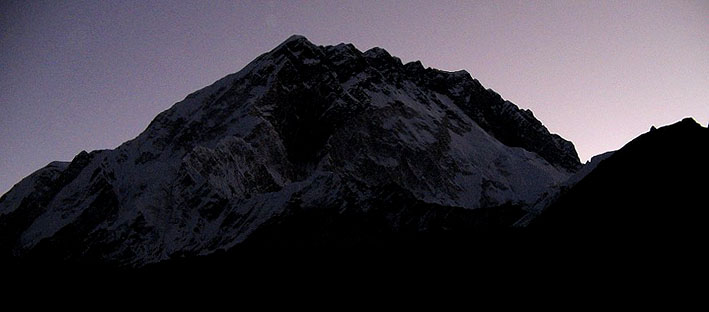
Nuptse at dawn
Moving on to Gorakshep


climbing to cross the Lobuche Pass

almost there

the Lobuche pass with the Khumbu glacier wall on the left

and finally the khumbu glacier


the Khumbu ice fall at a distance ….the first hurdle before camp 1 on the way to the summit

Pumori & Kalapathar


The Base Camp

Gorak Shep beside the dry lake at the base of Kalapathar

up Kalapathar leaving Gorakshep & the glacier below…

if you see hard y’can see the round helipad on the dry lake bed…on the left..thats where the rescue choppers land

Day 11
Here I was standing in front of this massive mountain as I realised my moment of truth.
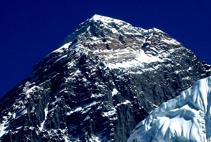
Everest has been a dream for plenty of people & mine ended at this point…this is the closest I ‘d get to see it and my mission was accomplished . Inhaling the cold crisp air & looking up at the summit I wondered why I was here , what made me tread miles to come here just to have a look at this…thinking straight at that altitude is not easy…the mind tends to get confused but if you can bring it together once and keep it at a point you realise this is quite a place very unlike any other in the whole planet. It’s been standing there silently for ages witness to the very core of existence of the human race…hard to believe his massive mountain the highest on this planet at 29,035 ft actually rose from the sea about 50 million years ago…fossils of marine life , although deformed & difficult to recognise, have been found at heights above 26,000 ft in the Himalayan chain.

Mt Everest, like the rest of the Himalayas, rose from the floor of the ancient Tethys Sea. Eventually the marine limestone was forced upward to become the characteristic yellow band on the top of Mount Everest. Beneath the shallow marine rock lies the highly metamorphosed black gneiss (foliated, or layered, rock) of the Precambrian era, a remnant of the original continental plates that collided and forced up the Himalayas. It’s covered with huge glaciers that descend from the main peak and its nearby satellite peaks. The mountain itself is a pyramid-shaped horn, sculpted by the erosive power of the glacial ice into three massive faces and three major ridges, which soar to the summit from the north, south, and west and separate the glaciers. From the south side of the mountain, in a clockwise direction, the main glaciers are the Khumbu glacier, which flows northeast before turning southwest…

…running the full length of the Himalayan chain is a thick slab of metamorphic rock, the greater himalayan series, which formed in the mid-crust at an earlier stage of the evolving collision between India and Asia. Its appearance at the surface today is the result of movement on two spectacular shallow-dipping fault systems at the base of the slab, the main central thrust zone and at the top the extensional faults of the south tibetan detachment system (STDS). Along much of the Himalaya, sediments rest almost directly on high-grade gneiss across the STDS, but in the Everest area there is an intervening unit of lower-grade schists that offers a vital insight into how the top of the slab developed. Unfortunately, these are mostly exposed in near-vertical faces at extreme altitude, and good samples are few. The upper part of Mt Everest is seen here from the south. The topmost strata are grey limestones that in places contain fossil fragments. The highest rock sample collected is of limestone, from just below the ridge at the right side of the photograph. Below this is the so-called Yellow Band, made of pale yellow-brown metamorphosed limestone. The break in metamorphic grade here marks the position of an important low-angle extensional fault – the Qomolangma detachment…beneath the Yellow Band are the black schists of the Everest Series.

How tall is the highest ?
First perhaps to gauge the summit’s enormity was the ‘chief computer’ at the office of the great Trigonometrical Survey of India’ – Radhanath Sikhdar had reckoned in 1852 that peak XV at 29,002 ft was higher than hithero measured. On realising the weight of the discovery, Sikhdar the Bengali ‘computer’ is supposed to have rushed into the office of his supervisors, shouting …’sir…I have discovered the highest mountain in the world’ . In 1865 , at the suggestion of the surveyor general Sir Andrew Waugh , peak XV was renamed Mount Everest in honour of his predecessor Sir George during whose tenure (1829 – 43) the peak was surveyed. Sikhdar had worked for Sir George for 5 years . For more than 100 years after its height was first determined , the great mountain pinnacle would not be conquered .

Day 12
I was right in front & looking up to the top of the world , the human race took centuries to conquer .
The first seven attempts on Everest, starting with a reconnaissance in 1921, approached the mountain from Tibet, where a route to the summit via the North Col and North Ridge seemed possible. On 6th June 1924 two British climbers 38 year old George Mallory and 22 year old Andrew Irvine were on the north col at 23,100 ft poised to make a push for the summit . They were kitted out in the typical climbing outfits of the time..heavy wool, flannel & wind proof gabradine . Their footwear was leather boots and woollen socks. In addition to their personal gear they carried cumbersome oxygen equipment weighing close to 30 pounds. After a breakfast of tinned sardines, biscuits , tea & hot chocolate..mallory & irvine set off , looking to reach the summit in 3 days. Following well behind in support was expedition geologist Noel Odell . After spending the night of 7th June at camp 5 , Mallory & Irvine pushed on to camp 6 at 27,00 ft…2000 ft below the summit . They left their camp early the next morning heading for the top . Odell last sighted them on 8th June at 12.50 pm. He estimated they were at the daunting second step , a steep wall of rock at around 28,000 ft . The two were about 4 hrs behind schedule but according to Odell …” I could see that they were moving expeditiously as if endeavouring to make up for lost time …” then clouds closed in, the weather began to deteriorate – and Mallory & Irvine were lost to legend.
The subject of the great debate has always been …’did they or didn’t they make it to the top ?’ . Had the most prized peak in mountaineering already been touched by the time Hillary & Tenzing got there in May 1953 ? No one so far knows the answers…
In 1933 , an ice axe was found along the route at 27,760 ft , later identified as Irvines . 40 years on , in 1975 a chinese climber stumbled on a body about 750 ft below where the axe had lain , and reported it as an english dead . Could that have been the body of Andrew Irvine ? the only evidence to support the idea that the two had indeed made the summit would be on film in the kodak pocket camera that Mallory carried . Find the camera & one could hope to see a summit photo .
On the 75th anniversary of their disappearance , an expedition set out to find the bodies of the two & hopefully the missing camera. The quest of this 1999 Mallory & Irvine research expedition was the El Do rado of climbing mysteries. The expedition was led by Eric Simonson . The story began on 1st May 1999 as they crossed a vertiginous snpw terrace on the north face towards fellow expedition member Conrad Anker . They had been searching for less than two hours when at Anker’s feet , frozen in a 75 year old self arrest , was a boby , its torso alabaster white & almost perfectly preserved . The area they were combing was above 26,000 ft . A white snow terrace the size of 12 football fields , its 30 degree slope ending in a 7,000 ft drop to the central Rongbuk glacier below. Yet here was the corpse , lying fully extended , face down & pointing uphill . The head & upper torso was frozen into the rubble that had accumulated over the decades. The arms powerfully muscular still , extended above the head to strong hands that gripped the mountain side . Flexed finger tips dug deep into the gravel. Legs extended downhill, one broken the other protectively crossed over it . The natural fibre of the clothes , the fur lined leather helmet , the kind of rope that was around him were also so eloquent . As they stood there this mute but strangely peaceful body was giving them answers to the question that everyone had been asking for three quarters of a century . The hobnailed boots were the give away . No climber had died at this altitude between 1924 & 1938 & hobnailed boots had given away to crampons by the eve of World War II .
The expedition uncovered numerous artefacts from Mallory’s body plus an abandoned oxygen tank…but the question still persists…’did they make it to the summit ?’ We know Mallory died in a fall. we also know the two men had climbed higher than anyone until 1953 . One can almost see that the two were descending in the dark when the fall occurred . with no lamp at hand groping in pitch darkness will make a fall seem inevitable. This desperate situation will combine fatefully with their being utterly exhausted from the last ditch attempt, freezing & dehydrated . Even so the indomitable Mallory was heartbreakingly close to the safety of camp IV . This would have been closer than anyone ever imagined. The question still remains..’had Mallory & Irvine been to the top or had they turned back before reaching it ? ‘ Its more than reasonable to thin that to be within 1000 ft of claiming the third pole would have been irresistible to Mallory regardless of the late hour or his condition. In ‘ Ghosts of Everest ‘ the author draws the following conclusion ‘ A dispassionate analysis of that information suggests it is more likely than had previously been thought that they did make it – but it is still far from certain ‘
The camera still has not been found – the great debate rages on.

The New Zealander Edmund Hillary and the Nepali Sherpa Tenzing Norgay are credited for being the first people to reach the summit on May 29, 1953. Since then, many other individuals have sought to be the first at various other accomplishments on Everest, including many alternative routes on both the north and south sides. Italy’s Reinhold Messner has climbed Everest twice without oxygen, once in four days. He is also the first to solo climb Everest, which he did in 1980. Ten years earlier, Yuichiro Miura of Japan had been the first person to descend the mountain on skis. In 1975, Junko Tabei, also of Japan, was the first woman to climb Everest. The first disabled person to attempt Everest was American Tom Whittaker, who climbed with a prosthetic leg to 24,000 feet in 1989, 28,000 feet in 1995, and finally reached the summit in 1998. The first blind man to reach the summit was Erik Weihenmayer in 2001. The record for most ascents belongs to Sherpa Ang Rita, who has reached the summit ten times. Overall, more than 600 climbers from 20 countries have climbed to the summit by various routes from both north and south. Climbers’ ages have ranged from nineteen years to sixty. At least 150 people have perished, most commonly by avalanches, falls in crevasses, cold, or the effects of thin air. Climbing on Everest is strictly regulated by both the Nepalese and Chinese governments. Permits cost thousands of U.S. dollars , and are difficult to obtain, and waiting lists extend for years. Treks to Everest base camp, minus the summit attempt, are becoming increasingly popular on both the north and south sides of the mountain.
this years tourist count at the sagarmatha national park entrance at jorshale

Day 13
This same place was witness to tragic dramas over the ages. This same mountain I was staring at was also witness to tragic dramas . The 1996 Everest disaster refers to a single day of the 1996 climbing season, May 11 ’96, when eight people died on Everest during summit attempts. In the entire season, fifteen people died trying to reach the summit, making it the deadliest single year in Everest history. The disaster gained wide publicity and raised questions about the commercialization of Everest. Journalist Jon Krakauer, on assignment from outside magazine, was in one of the affected parties, and afterwards published the bestseller ‘Into Thin Air’ which related his experience. Anatoli Boukreev, a guide who felt impugned by Krakauer’s book, co-authored a rebuttal book called ‘The Climb’. The storm’s impact on climbers on the mountain’s other side, the North Ridge, where several climbers also died, was detailed in a first hand account by British filmmaker and writer Matt Dickinson in his book ‘The Other Side of Everest’.
Adventure Consultants’ 1996 Everest expedition consisted of eight clients and three guides (Rob Hall, Mike Groom and Andy Harris). Among the clients was Jon Krakauer, a journalist on assignment from Outside magazine. Hall had brokered a deal with Outside for advertising space in exchange for a story about the growing popularity of commercial expeditions to Everest.
Shortly after midnight on May 10 ’96, the Adventure Consultants expedition began a summit attempt from Camp IV, atop the South Col. They were joined by climbers from Scott Fischer’s Mountain Madness company, as well as expeditions sponsored by the governments of Taiwan & India. The expeditions quickly encountered delays. Upon reaching the Hillary Step, the climbers discovered that no fixed line had been placed, and they were forced to wait for an hour while the guides installed the ropes. Because some 33 climbers were attempting the summit on the same day, and Hall and Fischer had asked their climbers to stay within 150 m of each other, there were bottlenecks at the single fixed line at the Hillary Step. Many of the climbers had not yet reached the summit by 2:00 pm, the last safe time to turn around in order to reach Camp IV before nightfall. Hall’s Sirdar, Ang Dorje Sherpa, and other climbing Sherpas waited at the summit for the clients. Near 3:00 pm, they began their descent. On the way down, Ang Dorje encountered client Doug Hansen above the Hillary Step, and ordered him to descend. Hansen did not respond. When Hall arrived at the scene, he sent the Sherpas down to assist the other clients, and stated that he would remain to help Hansen, who had run out of supplementary oxygen. At 5:00 pm, a blizzard struck the Southwest Face of Everest, diminishing visibility and obliterating the trail back to Camp IV. Shortly afterwards, Hall radioed for help, saying that Hansen had fallen unconscious but was still alive. Adventure Consultants guide Andy Harris began climbing to the Hillary Step at 5:30 pm with supplementary oxygen & water.
May 11 – 4:43am, Hall radioed down and said that he was on the South Summit. He reported that Harris had reached the two men, but that Hansen had died of hypothermia sometime during the night and that Harris was missing as well. Hall was not breathing bottled oxygen, because his regulator was too choked with ice. By 9:00 am, Hall had fixed his oxygen mask, but indicated that his frostbitten hands and feet were making it difficult to traverse the fixed ropes. Later in the afternoon, he radioed to Base Camp, asking them to call his wife, Jan Arnold, on the satellite phone. During this last communication, he reassured her that he was reasonably comfortable and told her, “Sleep well my sweetheart. Please don’t worry too much.” Shortly thereafter, he died, and his body was found on May 23 by mountaineers from the IMAX expedition. Anatoli Boukreev was the lead climbing guide for the MM expedition headed by Scott Fischer. The team included eight clients, each of whom had paid approximately $65,000 for a fully-guided summit attempt of Everest . Pete Schoening had decided not to make the final push to the summit while still at Everest Base Camp. The team began the assault on the summit on May 6, planning to bypass Camp I and stop at Camp II for the night. However, when the guides reached Camp I, they found Kruse suffering from altitude sickness and possible cerebral edema in one of the tents. Kruse returned to Base Camp with Fischer for treatment.
Starting around midnight on May 10, Boukreev, Neil Beidleman, Scott Fischer and a team of sherpas began guiding the six remaining clients to the summit, starting from Camp IV on the South Col (7,900 m/25,900 ft). Delays at the South Summit, caused by the failure of the climbing Sherpas to set the fixed ropes by the time the team reached that point, cost the team an hour on the ascent. Climbing without supplementary oxygen, Boukreev reached the summit at 1:07 pm. He began his descent to Camp IV at 2:30 pm. By that time, Adams and Klev Schoening had reached the summit, but Beidleman and the remaining four clients had not yet arrived. Boukreev recorded that he reached Camp IV by 5:00 pm. The reasons for Boukreev’s decision to descend ahead of his clients are disputed. Boukreev maintained that he wanted to be ready to assist struggling clients farther down the slope, and to retrieve hot tea and extra oxygen if necessary. Journalist Jon Krakauer, who climbed with the Adventure Consultants expedition, asserts that Boukreev’s refusal to use supplementary oxygen and lack of warm clothing made it too dangerous for him to wait at the summit for the remaining clients. A blizzard struck at 4:00 pm, causing difficulties for the descending team members. The snow buried the fixed ropes and obliterated the trail that the team had broken on the ascent, resulting in several climbers getting lost on the South Col. Beidleman, Schoening, Fox, Madsen, Pittman, and Gammelgaard, along with Adventure Consultants’ Mike Groom, Beck Weathers, and Yasuko Namba, wandered in the blizzard until midnight. When they could no longer walk, they huddled some 20 m from a drop-off of the Kangshung Face.
Near midnight, the blizzard cleared enough for the team to see Camp IV, some 200 m away. Beidleman, Groom, Schoening, and Gammelgaard set off to find help. Madsen and Fox remained with the group to shout for the rescuers. Boukreev located the climbers and brought Pittman, Fox, and Madsen to safety. He decided that Weathers and Namba were too close to death to move. Fischer, meanwhile, had not reached the summit until 3:45 pm. He was ill, possibly suffering from HACE, and exhausted from the ascent. Fischer was unable to descend below the South Summit (8350 m/ 27395 ft) in the storm. The following day, the climbing Sherpas located Fischer, but his condition had deteriorated so much that they were only able to give palliative care. Boukreev made a subsequent rescue attempt, but found Fischer’s frozen body at around 7pm.
below is the memorial of Scott Fischers we came across at Dugla memorial ground while on our way to Lobuche


The ’96 disaster is well known across the planet…thanks to Jon Krakauer’s ‘Into Thin Air’, and two movies made out of the book, the names of Rob Hall , Scott Fischer, Yasuko Namba, Doug Hansen & Andy Harris are also well known. What is not too well known are the other three fatalities of the day, who were the climbers from the Indo Tibetan Border Police expedition from India. The expedition was led by Commandant (equiv to Lt. Col) Mohinder Singh, and is credited as being the first Indian ascent of Everest from the North side. On May 10, 1996 by Subedar Tsewang Samanla, Lance Naik (equivalent to Lance Corporal) Dorje Morup and Head Constable Tsewang Paljor were part of a six man summit attempt from the North Side. The team had six members and were the first team of the season to go up the North Face. It would also be their responsibilities to fix the ropes during ascent and break the trail to the top, a task that has its own share of difficulties. The team was caught in the blizzard above Camp IV. While three of the six members turned down, Samanla, Paljor and Morup decided to go for the summit. Being a traditional type of an expedition, the summit team did not have any sherpas to guide them in their ascent.
At around 6.00pm (3.45pm Nepal Time), the three climbers radioed to their expedition leader that they had arrived at the summit. While the Indian Camp was jubilant in their celebrations, some of the other mountaineers at base camp already expressed their reservations about the timing, which was quite late in the day to be on the summit. There is also a dispute whether the three actually reached the summit or not. Krakauer claims that the climbers were at 28,550 ft, roughly 500 ft short of the summit. This is based on the interview given by a later Japanese team to Richard Cowpens of the London Financial Express. Due to bad visibility and thick clouds which obscured the summit, the climbers believed they had reached the top. This also explained why the climbers did not run into the teams that summitted from the South Side. The three climbers left an offering of prayer flags, katas and pitons . Here the leader Samanla decided to spend extra time for religious ceremonies and instructed the other two to move down. There was no radio contact after that. Back at the camps below, anxious team members saw two headlamps moving slightly above the second step – at 8570 meters. None of the three managed to come back to high camp at 8320 meters.
The next day, two Japanese climbers, Hiroshi Hanada and Eisuke Shigekawa, of the Fukuoka Mountaineering Club, aided by three Sherpas, making the summit attempt found one of the climbers shortly above First Step. The climber, (whom Krauker believes to be Paljor) was still moaning and frostbitten from exposure over the night. The Japanese climbers left him and sent for the summit. After they climbed the second step, they ran into the other two climbers, probably Samanla and Morup. Krakauer notes “No words were passed, No water, food or oxygen exchanged hands. The Japanese moved on …”. The apparent indifference of the Japanese climbers was inexplicable as the Indian expedition leader told later, “The Japanese had initially pledged to help the search for the missing Indians. But hours later, they pressed on with their attempt to reach the summit, despite bad weather.” The Japanese team pressed on and summitted at 11.45am (Nepal Time). By the time the Japanese climbers descended, one of the two climbers was already dead. The other near death. They could not find any trace of the third climber farther down. Much discussion ensued on why the Japanese did not help the Indian climbers. While the consensus suggests a rescue mission at such a high altitude was out of scope, it is not understood why the Japanese did not offer any succor to the dying Indians .
Unbelievably, Weathers lived to tell the story. He relived his experience of miraculously surviving the deadliest storm in the history of Mt. Everest , from a relatively smooth beginning, to a sudden blizzard that killed a number of his fellow climbers and caused him to lose his nose, his right hand and part of his left hand. Practically bringing himself to tears, Weathers relived the tragic deaths of his fellow climbers as they froze in the bitter cold. One particular story that stood out was that of a team member named Rob who was still descending from the peak as the storm hit. Knowing that he would slowly freeze to death, the other climbers phoned Rob’s pregnant wife and put her on the radio so that he could talk to her before he passed away. Weathers mournfully relayed their final moments with each other. “And she said, ‘Sleep well, my darling. I’ll be OK,'” Weathers said. “He didn’t know that the radio was still on, and we could hear him quietly weeping.” Weathers then explained his reaction to the revelation before he lost consciousness, that he would probably not survive the event. “I realized, I’m not so cold anymore,” he said. “Even in my befuddled state, I knew that this wasn’t a good thing.” He continued, “Slowly, gently, inexorably — coldness moves through you, and darkness takes you.” Unconscious, covered in snow and ice and presumed dead, Weathers was left alone on the most ruthless mountainside on earth. He said that the other team members even called his family and told them that he was dead. And then,” he said, “I opened my eyes.” Barely alive, and his body broken by frostbite, he walked back to the base camp and eventually made it home. The story of Beck Weathers’ triumphant survival is told in his book, Left for Dead: My Journey Home from Everest .
Weathers painted word pictures of Everest, saying that the peak of mountain is as high as most airliners fly and that the winds blow at 150 to 200 miles per hour, except for twice a year “when you can run up and tag the top, then leave.” There are blocks of ice the size of multi-blogy buildings that teeter and fall, wiping out anything below them, and the air is so thin that if a person was instantaneously transported there, he or she would immediately die. Climbers ease into Everest, he explained, first climbing up and down in short stints, higher and higher, to get used to the lack of oxygen. Climbers eventually reach heights where the lack of air is so great that they cannot eat, drink or sleep. The only thing that keeps them alive is the internal furnace of their bodies.
Weathers described the people he was with on the climb–some with affection, some with distaste but without condemnation. The group, he said, had climbed to Camp 4, the last resting place before the summit push, where they planned to rest three hours, then climb all night and morning to make the top of Everest by 2 pm. He explained that if a climber doesn’t turn around by that time, it is unlikely that he or she will make it back alive to Camp 4. According to Weathers, some of the climbers were not in good shape and should never have attempted to reach the summit. He himself realized that he could not attain the goal when partial blindness set in, caused by the high-altitude lack of air pressure. He told group leader Rob Hall that he couldn’t go on. Hall made Weathers promise that he would wait for the group to return from the summit before trying to make it to Camp 4. But Hall never returned, dying in the unfolding tragedy on the mountain. Eventually, much later in the day, realizing that something had gone terribly wrong, Weathers began his descent with other straggling climbers. Tied by a rope to one of the men, Weathers–still blind– struggled on, but within a short distance of Camp 4, a sudden storm struck. The returning climbers became lost in the whiteout. When the storm broke, a decision was made for the strongest members of the party to find the camp and get help. The weakest, including Weathers, were left behind to lie down next to each other in the snow. They yelled at each other; they shook and kicked each other–did anything they could to keep each other awake and alive.
During the night, some of those left behind were rescued, but Weathers and another female climber, who appeared the closest to death, were left behind. The next day, they were stumbled across climber Stewart Hutchison and native tribal Sherpas. Both were barely alive–in hypothermic comas–and out of necessity, left behind again to die. Sometime afterward, Weathers said, a miracle happened. He opened his eyes, “and as plainly as I see you here before me today, I saw my family. ” He was filled with a “sense of melancholy that I had not said good-bye and I love you. ” His voice broke as he added, “It was just not acceptable.”
Weathers said he got up and started to walk. He eventually stumbled into the camp. His face was eaten away by frostbite and both of his hands were frozen. He was too weak to make the trek down the mountain, and again, he believed he was a dead man. However, Weathers’ wife, Peach, had other ideas. First told her husband was dead, a second call informed her that he “wasn’t quite as dead as they’d thought.” Peach Weathers organized a extraordinary rescue. She enlisted the commitment of a Nepalese army pilot to fly a helicopter at a higher altitude than any had flown before. It was a close to a suicide mission, Weathers said, as any pilot could choose. It was also a “one-off.” The helicopter could try to land once and carry down a single passenger. Just before the chopper reached Weathers, Sherpas literally dragged down another climber whose feet had frozen. Weathers gave up his place on the chopper to the other climber. He said he sat in the silence after it had gone, realizing he had lost his last chance at life. Then he heard the sound of the helicopter returning. To him, the pilot became the greatest of all heroes. “We were separated by language, culture, religion, and the entire breadth of the world, but bound together by humanity.”
We were lucky to meet this great man Lt Coln K C Medan…the pilot at the Buddha lodge in Lukla

and his rescue machine parked at the Lukla airport
Weathers made it home alive. Both his hands and nose were amputated, replaced with a prosthetic or reconstructed, but he rediscovered the joy of living with a family he had almost lost. Before the Everest tragedy, Peach Weathers had been on the verge of divorcing her husband. “The relentless pursuit of success and goals and ambition had dragged out of life what was most precious,” he explained. “I traded my hands and my face for my family and I accept that bargain. In the end, all that matters is the people you hold in your heart and those who hold you in theirs.”

Day 14
mission accomplished..whispering my silent goodbye I started the descent..not sure if I’d ever come back here again in this life..

trekkers at such high altitude have much more rapid breathing and pulse rates as their bodies try to obtain more oxygen. In addition, they are not able to digest food well and often find eating unappealing, they sleep poorly, and often find their thinking to be confused. These symptoms are manifestations of oxygen deprivation in the body tissues, which makes any effort difficult and can lead to poor decisions being made in an already dangerous environment. Ours was though pre decided & we headed down to Gorakshep.

It’ll be a very long way down all the way to Dughla..

the feeling of fulfilment engulfed us as we moved down…though the body was screaming rest we knew we had a long way to go and for days…

leaving the glacier

and the lakes within it starting to freeze with the onset of winter

with the last look at the base camp at the base of the Kumbhu icefall which has & will be the launching base of many more summit attempts

and then moving away from the glacier itself


finding the trail in the maze of boulders was quite difficult


the glacier wall moving away from our trail down

reaching the top of the Lobuche pass

and the trails down from the pass to lobuche with the glacier on the left…


approaching Lobuche around 4 in the evening..with a short rest we moved on towards dughla


as we left lobuche it started getting cloudy & foggy


crossing the moraine


approaching the dugla pass

completely exhausted before the long descent down the dugla pass…still a long way to go


finally the dughla lodge at sight

our longest day of the trip ended after about 13 hrs on the trail

Day 15
with the body well acclimatised now sleep was sound of course after a couple of painkillers and appetite was increasing slowly..started off after breakfast for another very long day..


the kumbhu glacier melts into a stream beside dughla

which flowed down to join the Lobuche khola


contrasts & distances were awesome


crossing the Periche pass


leaving behind shomare


approaching Pangboche…


leaving the Pangoche entrance

the high bridge before entering the dense rhododendron forests before Tangboche

finally top of the meadow at Tangboche..with our trail in the sun…behind

descending from Tangboche towards the river bed

slowly getting dark


almost dark …crossing the Pungitenga bridge

finally the only teahouse lodge at punki tenga beside the river. Water was available is plenty throughout & of very good quality.

yak meet hanging in the kitchen

dinner

Day 16
sun cream at the start of the day…but wasn’t to much effect


back to Namche


finally our lodge for the night at Monjo

it was Humtu’s 37th birthday …& how better to celebrate that with chang…we were still at an altitude but well acclimatised…going down & was looking forward to an ebc party to end with….but this was just the beginning of the partying nights…chakre & bala had kukri rum & Aruna with her favourite coke….chang is a home made beer served warm…tastes a little sour but the kick was great…possibly due to a tired body taking to the drink or altitude..or both..

and the birthday pancake

but my friend was not happy..

..so more chang..

…and the effect…blame the altitude..

Day 17


first beer after days

the yak man


and sahib with his favourite kukri again celebrating finishing the last trek day

Day 18
..next morning Lukla ATC..

the runway


the parking bay with the famous machine

with this weather our flight was cancelled after getting boarding passes…an extra night at Lukla ..

so…party with the best girls in town & the famous pilot

ula – la…la la ule o…

ula – la… la la la…le-o

disco

samba

hare rama

radhe krishna

..I’m fine honey..don’t worry…will reach on time..

back to the nepali thali for dinner

Day 19
..sudoku in the morning as we waited for the sky to clear up & the airport to open for our flight back..

..much awaited departure..

..running down the runway slope


take off before turning to the left

Kat airport

..that’s the plane slated to take us back home…which we’ll miss..

..my friend bribed the yeti guys at lukla & bought his passage back on the first flight of the day…later though we learned from them the deal was only for him….however we luckily made it back to Kat by the days last flight & missed our connecting one to Kolkata…somehow managed tickets for the next evening’s ktm – ccu flight & got an extra day at Kat..

..un-bathed & almost unfed for 15 days..hunger screamed mayhem…steak for dinner seemed just an appetiser..

Day 20
time for the last shot..

but before that there was just enough time to take back home on my chest a piece of..

..my good friend..

goodbye..

It’s impossible to capture this trek on camera not just ‘cos of the un-measurable beauty of the spaces but its a very personal journey which can only be experienced when one makes it..and thereby feels it. Humans by nature are always looking out to explore..this surely opens a different world for that..would strongly recommend to all..


