China India and Water
11 min read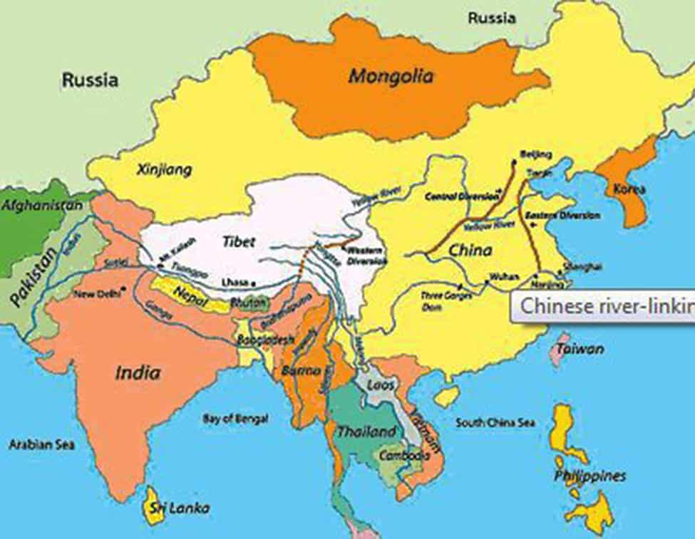
Some facts about China & Tibet
– Taking the first step toward what has become 70 years of oppression now, China’s People’s Liberation Army invaded Tibet, killing more than 10,000 in 1950
– Repeated attempts by The Dalai Lama to negotiate with China were dismissed.
– In 1950, the 15-year-old Dalai Lama was forced into full leadership of Tibet.
– In1951 a Tibetan Delegation was forced to sign the 17
– Point Agreement, promising ‘Measures for the Peaceful Liberation of Tibet’.
– Around 1959, The Dalai Lama went to China to speak with Chairman Mao Zedong Mao told him ‘Religion is poison..Tibet and Mongolia have both been poisoned by it’
– Same year, the Chinese retaliated against the Tibetan resistance, killing more than 87,000.
– On March 17 – 1959, The Dalai Lama escaped His sacred homeland, seeking political asylum in India.
– The Chinese declare martial law as thousands of Tibetan refugees begin pouring into India.
– During Chairman Mao Zedong’s reign Tibetans suffered through the Tibetan Cultural Revolution experiencing some of the worst human rights abuses ever known . All old ideas, old culture, old customs and old habits were destroyed. Before the Chinese occupation, there were 6,000 Tibetan monasteries in Tibet. After the Cultural Revolution, there are six left. Hundreds of thousands of Monks, Nuns and civilians are imprisoned or killed for wearing traditional hairstyles and clothing, engaging in traditional song or dance, or voicing their religious beliefs. Rituals such as prostrations, mantras, prayer wheels, circumambulation, throwing tsampa and burning juniper or incense are strictly prohibited. Anything representing the cultural identity of the Tibetan people was eradicated.
– More than 2,50,000 Tibetans died in prisons and labor camps. Tibetan women were raped, sterilized and forced to have abortions. Children were shut off from Tibetan culture and subjected to beatings by teachers and authority figures. Nun’s accounts of their prison experiences indicate they were targeted by the Chinese. They were subjected to extreme methods of torture. Dogs were used to bite them , their faces and torsos were burned with cigarettes, and electric batons were used on their genitals. Tibetan refugee children report that teachers and other authority figures subjected them to beatings using rubber clubs, whips, belts, chairs, electric wires and other instruments.
– China inflicted severe damage to Tibet’s environment. Toxic waste was dumped into rivers, forests were clear-cut , endangered species were hunted for sport, nucleartesting facilities were built. Hundreds of thousands of Tibetans died from famine and disease. The Chinese began building facilities for the development of nuclear weapons and began nuclear testing in the Tibetan plateau. In just 30 years, 25 % of Tibet’s forests were clear-cut, putting $54 billion into Chinese pockets. In the 1980s, this rapid deforestation caused 5 billion tons of soil to be lost to erosion every year, making the Yellow River flood. China currently has at least 300 to 400 nuclear warheads, many of which are in the Tibetan plateau. China declared in 1991 the ‘Year of Tibet’ and began bulldozing historic Tibetan buildings and homes in the Barkhor, the central square of Lhasa, Tibet’s capital.
Water
– It is estimated that by 2025 , over half of the world’s inhabitants will be directly affected by water scarcity
– Most of them will live in either China or India
– China has access to about 7% of the world’s water resources , but has 20% of the global population
– India possesses about 4%of the water resources with only a slightly smaller populace
– Both countries along with eight other Asian nations and 47 per cent of the world’s people, are heavily dependent on the Tibetan Plateau for water.
– An estimated 70 percent of China’s rivers are polluted, leaving an estimated 300 million people with limited access to clean water.
– Almost half of the world’s population lives in the watersheds of the rivers whose sources lie on the Tibetan Plateau.- Scientists say glaciers on the Tibetan Plateau are receding faster than in any other part of the world , if the rate continues, most will gone by 2035.
– There are more than 1000 lakes on the Tibetan Plateau, including the world’s highest salt lake – Namtso
– Both sourced in the Tibetan Plateau, the Yangtze (Chang
Jiang) River and the Yellow River serve roughly 520 million people in China.
– The Yangtze River is the third-longest in the world, after
the Amazon and the Nile.
– Six major Asian river basins begin in the Tibetan Plateau – the Indus (India, Pakistan); the Ganges (Nepal, India, Bangladesh); the Brahmaputra (India, Bangladesh); the Salween (China, Burma, Thailand); the Mekong (China, Laos, Thailand, Cambodia, Vietnam); and the Yangtze (China).
– Over 45,000 glaciers seasonally drain into these rivers, but experts warn that due to global warming they are shrinking at twice the rate of other glaciers worldwide.
– This factor, combined with increasing water consumption, desertification, rapid industrialization and pollution, mean that demand for the pristine and previously plentiful water of the Tibetan Plateau is increasing. Yet, it is also drying up.
– With more than a quarter of its land classified as desert, China is one of the planet’s most arid regions.
– Beijing is besieged each spring by raging dust storms born in Mongolia where hundreds of square miles of grasslands are turning to desert each year.
China’s long term Strategy
James Bond films have an overdose of action, but they have one thing that is close to reality , the central plots usually spot global fault lines right. In Quantum of Solace, the plot involves a rogue organisation trying to trade off lucrative water supply contracts in exchange of support for a coup attempt by a renegade military commander.
It’s really is no longer the quest for territory or even oil, but it may be that the squabble for water resources could trigger the conflicts of the future. And closer home, in India’s immediate neighbourhood, water issues are creating problems. Trans-boundary water supply is developing into a major, if largely unremarked upon as yet, politico-security issue for Asia’s two giants.
So the role of today’s Chinese leaders would be to find water to sustain agriculture and ultimately feed the people of China. But water is disappearing fast from the Middle Kingdom. One of the solutions for China is to divert the water from the South to North. The water diversion project is an essential part of the 10th Five-year Plan.
Water will be diverted from the South via three channels in the eastern, central and western regions, respectively. The western route draws water to the upper reaches of the Yellow River to solve water shortage in the north-western regions. This is where the waters of Tibet are vital…another reason for Mao to ‘liberate’ Tibet. Most of Asia’s waters flow from the Tibetan plateau, the principal watershed in Asia. The Roof of the World is the source of Asia’s ten major rivers. Tibet’s waters flow down to eleven countries and are said to bring fresh water to over 85 percent of Asia’s population, approximately 50 percent of the world’s population
It’s roughly estimated that 10-20 percent of the Himalayan region is covered by glacial ice while an additional area ranging from 30-40 percent has seasonal snow cover. Himalayan glaciers cover around 100,000 square kilometers and store about 12,000 cubic kilometers of fresh water: The most incredible water tank one can imagine.The perennial run of the rivers originating from these glaciers also result in a stable flow of water to regions which are dominated by monsoon rainfalls (with rain falling during only a few months of the year).
Consequently, the Tibetan rivers, independent of seasonal precipitation patterns, are an important factor in sustaining hydrological regimes of South Asia. Four of the world’s ten major rivers, the Brahmaputra (or Yarlung Tsangpoin Tibet), the Yangtze, the Mekong and the Huang Ho (or Yellow River) have their headwaters on the Plateau. Other major rivers originating in Tibet are – the Salween, the Irrawaddi, the Arun, the Karnali, the Sutlej and the Indus.
About 90 percent of their runoff flows downstream to China, India, Bangladesh, Nepal, Pakistan, Thailand, Myanmar, Laos, Cambodia and Vietnam. For us in South Asia, of main concern are the Brahmaputra, the Indus, the Sutlej, the Arun and the Karnali whose waters give life to more than one billion people living downstream.
And taking about Tsangpo or Brahmaputra …it is the largest river on the Tibetan plateau, originating from a glacier near Mt Kailash. It is considered to be the highest river on earth with an average altitude of 13,000 ft. it runs 2,057 kilometers in Tibet before flowing into India, where it becomes the Brahmaputra
One of its interesting characteristics is the sharp U turn it takes at the proximity of Mt. Namcha Barwa (24,900 ft) near the Indian border. Like the Nile in Egypt, the Yarlung Tsangpo has fed the Tibetan civilization which flourished along its valleys, particularly in Central Tibet. The Yarlung Tsangpo enters in India in Siang district of Arunachal Pradesh. When it penetrates Assam, it is joined by two other rivers (the Dihang and Lohit). Entering Bangladesh, the river unites with the Ganga and is known as the Padma, before becoming the Meghna-Brahmaputra after merging with the river Meghna. Finally it divides into hundreds of channels to form a vast delta which flows into the Bay of Bengal.
When the Tsangpo reaches its eastern most point in Tibet, it takes a sharp U turn known as the Great Bend. In May 1994, Chinese geologists claimed that a remote Tibetan canyon is the world’s largest, bigger and deeper than the Grand Canyon. The Yarlung Zangbo Canyon, in the vast Himalayan range that encircles China, averages 5 kmm in depth and extends 317 km in length. (The Grand Canyon in Arizona is much smaller in comparison.) The Chinese Ministry of Water Resources indicated that Tibet’s Water Will Save China, underscoring the strategic importance of Tibet vis-à-vis water. It discusses the controversial South-North Water Transfer Project, which entails three man-made rivers channelling water from the Plateau to China’s arid north. This scheme will divert water from the Yarlung Tsangpo, Dadu and Jinsha rivers, which rise in the Plateau, and carry it to the Yellow River (Huang He) to provide water for human consumption, farming and industry
Three diversion routes are involved in the project but it is the diversion of the Yarlung Tsangpo that is the most controversial and technologically challenging of the three routes. The river flows eastwards through southern Tibet before making a spectacular U-turn at its easternmost point, called the Shuomatan Point or the “Great Bend,” just prior to entering India. Here it is joined by two other major rivers and from this point of confluence it is known as the Brahmaputra. It is also here that China plans to divert water. This diversion will mean that the amount of water in the Brahmaputra will fall significantly, affecting India’s northeast and Bangladesh. It will also severely affect agriculture and fishing due to an increase in water salinity and silting downstream.
The Tsangpo project will have two components –- one – the construction
of the world’s largest hydroelectric plant that would generate twice the
electricity produced by the Three Gorges Dam. The hydroelectric plant on the
Great Bend of Yarlung Tsangpo will dwarf all these projects with a planned
capacity of 40,000 Megawatts.
– and the second will be the diversion of the waters of the
Tsangpo which will be pumped northward across hundreds of kilometers of
mountainous regions to China’s northwestern provinces of Xinjiang and Gansu.
The implication of this enormity for India, cannot be ignored. It is not only the sheer enormity of the project which has to be considered, but the fact that if is accomplished, it will have ominous consequences for millions of people downstream . India and Bangladesh would be at the mercy of China for adequate release of water during the dry season, and for protection from floods during the rainy season. India knows from its own internal problems how difficult it is to solve a water dispute. When it comes to a trans-boundary question (where the boundary is not even agreed upon), it seems practically impossible to find a workable understanding.
A third untold aspect may be what we have experienced a couple of times…an event which occurred in June 2000 could be an illustration at a very reduced scale of what could happen if the Tsangpo project is some day completed. At that time, the breach of a natural dam in Tibet led to severe floods and left over a hundred people dead or missing in Arunachal Pradesh. It is not difficult to understand that areas downstream in Arunachal or Assam are extremely vulnerable to what takes place upstream in Tibet. A new dimension that the Chinese Army in Tibet, as part of an experiment, may have deliberately blasted the dam has been added to the already hazy picture. A few weeks later, a similar mishap took place on the other end of the Himalayas. Even three days after the disaster, the mystery of the flashfloods in the Sutlej, which wrecked havoc along its 200-km length in the state, remains unresolved.
Experts were at a loss to understand where the huge mass of water came from. Imagine a 50-ft high wall of water descending into the gorges of Kinnaur in Himachal Pradesh ! In a few hours, more than 100 persons died, 120 km of a strategic highway was washed away and 98 bridges destroyed.The details of this incident were similar to the Arunachal Pradesh’s one. A detailed study carried out a few months later by ISRO scientists confirmed that the release of excess water accumulated in the Sutlej and the Siang river (the Tsangpo) basins in Tibet had led to the flooding.
Nearly a year later, a leading weekly commented ‘ While the satellite images remain classified, officials of the Ministry of Water Resources indicate that these pictures show the presence of huge water bodies or lakes upstream in Sutlej and Siang river basins before the flash floods took place. However, these lakes disappeared soon after the disaster struck Indian territory. This probably means that the Chinese had breached these water bodies as a result of which lakhs of cusecs of water were released into the Sutlej and Siang river basins
Is it the art of combining different elements of these various forms of warfare that China is experimenting with, with one of the many ways of unconventional warfare identified as ‘environmental warfare’
Chinese River Linking Plan
This could potentially have dire consequences for both India and Bangladesh. It could be completed as the second phase of Chinese plan to interlink their rivers (this is how the first phase is). For India, the North-East is both food-surplus and water-surplus. After the diversion starts, the dry season flow could diminish by 20-30%. For a sandwiched Bangladesh, it’s time to share water with both Asian Giants – China and India. India is already taking 50% of Ganges water in the East. If Brahmaputra is compromised, it would virtually be a dry Bangladesh in lean season.
China continues it’s well planed treachery but soon they will have no one to support them globally for all the treachery they had been upto since ages and then the order is going to get different.


